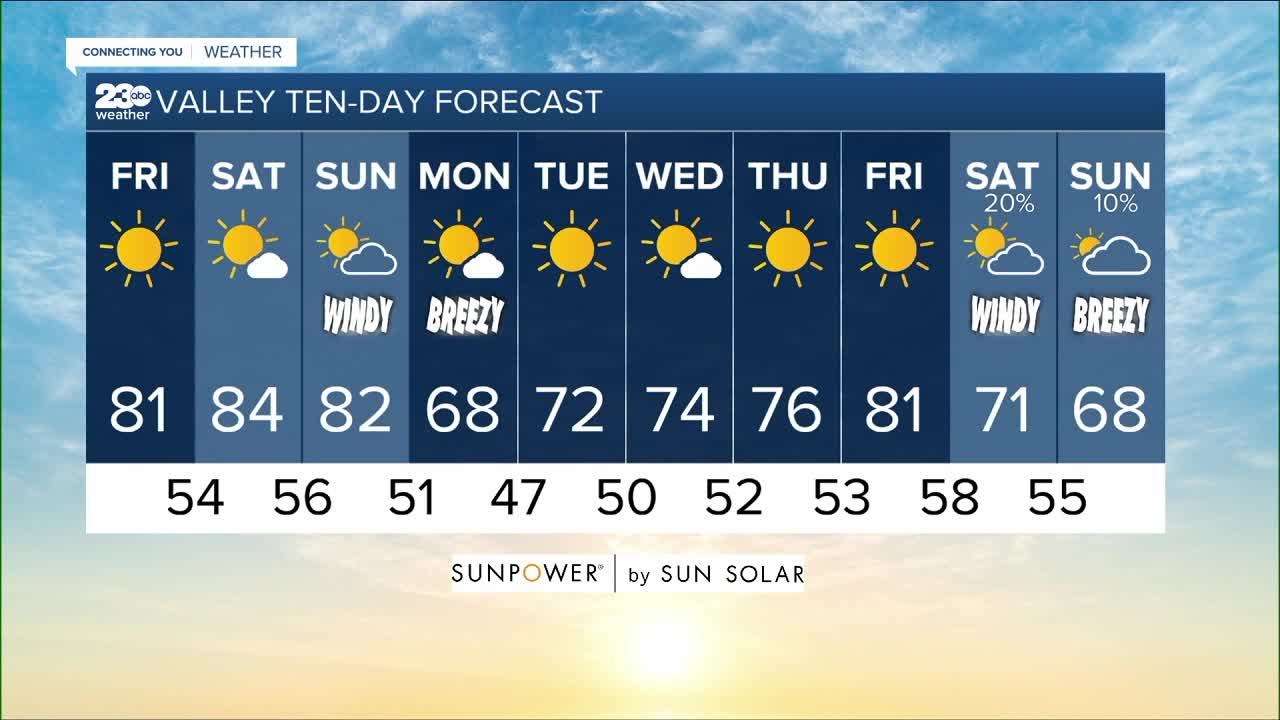


BAKERSFIELD, Calif. — High pressure continues to build off the coast today before sweeping onshore tomorrow.
That brings sunny and dry weather through the weekend with gradual warming to average low 80s in the valley today and the mid-80s tomorrow. The Kern River Valley and Kern Desert will enjoy sunny 70s through the weekend with a dry offshore flow, but that helps to keep the smoke away from the Alisal Fire burning to our southwest in Santa Barbara County. So air quality is in the moderate range today and should stay that way through the weekend. Tehachapi and Frazier Park see sunny upper 60s today with the low 70s tomorrow.
You'll notice temperatures drop a few degrees back to those low 80s here in the valley on Sunday, with slowly increasing cloud cover that afternoon. That's coming as we watch a trough of low pressure drop down from the Gulf of Alaska that day, sweeping it's cold front over Kern County overnight into early Monday.
Unfortunately we won't see any rain out of that system this far south, but we will get a dramatic drop in temperatures by Monday, similar to what we saw to start this week. But the first wind event of the season is always the "dustiest" after a long, hot, dry summer, so while we could see areas of blowing dust coming up on Monday, it won't be a widespread hazard like this past Monday. Take care if you'll be traveling for the weekend and plan to drive back through our mountain passes on Sunday afternoon and evening, as those increasing winds will make driving difficult, especially for high profile vehicles like motorhomes and trailers.
As I mentioned that cooling on Monday, it will be another Fall-feeling day of the upper 60s here on the valley floor, mid-60s in the Kern River Valley and just the mid-50s in the south mountains to start next week!
But then high pressure rebuilds over the region on Tuesday into Wednesday, with a quick return to the sunshine and stability, and that of course means warming right back to those 70s as we head into mid-week.
The long range forecast is hinting at the chance for a stronger storm to push toward the coast on Friday, so I'll call for some clouds and a cool down heading into next weekend, but we'll have to watch closely to see how much rain this system could bring to the state and if it will get close enough to Kern County to bring us more than just wind.
Find me on social media to share your weather photos and storm reports!
www.Facebook.com/ElainaRusk.23ABC
www.Instagram.com/ElainaRusk
www.Twitter.com/Elaina23ABC


